I’m sure we all know that Dublin City was founded by Vikings 988AD (which refers to the year of its status upgrade but not of its beginning as a town). That bit of knowledge is celebrated by a number of milk bottles that survive in the dusty wing of attics up and down the country. The city’s beginnings are a little more complex than that however, as firstly, the two main settlements were Gaelige in origin and it is older than 988AD.
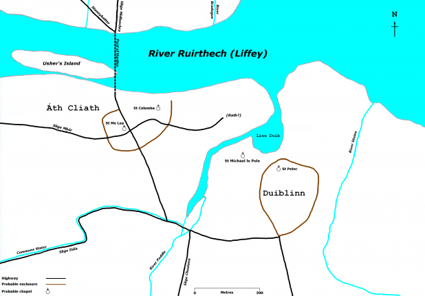
The city has two names Baile Átha Cliath (the town of the hurdled ford) and Dubhlinn (Black Pool). Both names relate to separate settlements located quite close to each other that would eventually form into the City of Dublin. Átha Cliath was a settlement that began it’s days in the mid 5th century located in the High Street/Cornmarket area of the city, which remains the oldest part of the city. The name “the town of the hurdled ford” relates to a latice of interlinked hurdles that made a make shift bridge at low tide at a natural ford were the Fr Mathew Bridge is presently located. The ford was also near an island (the original Usher’s Island) which made the passage less perilous.
The other settlement, Dubhlinn (Black Pool) was an ecclastical monastery located by a small dark pool of water fed by the Liffey located at the upper left hand corner (George’s Street end) of what is now Dublin Castle. The pool’s present day boundries (if it had remained) would be Golden lane, George’s Street and Dublin Castle (where the main body of the water was located in what is now a small park by the Chester Beatty Museum). It developed into the largest settlement of its type on the island.
The Vikings when they began to arrive to the Dublin region in the late 8th to early 9th century originally encamped on the southern side of what is the now the Memorial Gardens at Islandbridge (a Viking graveyard was found there in the 1980s). This was also the first Viking settlement in the whole of Ireland. There was another native Gaelige ecclastical centre in the area of the this early Viking settlement, up the hill at the monastery of Cill Maignham (Kilmainham) dating from the early 7th century AD.
These four settlements though in actuality quite close were separated by forests and rivers and would have seemed miles apart for the pragmatic purposes of travel in what were no doubt dangerous times.
Though Viking raids (most likely Norwegian in origin) were occuring with increasing frequency throughout the early 9th century, it would not be until 841AD when they conquered the Dubhlinn settlement and within the same period moved further in and conquered Átha Cliath. It is only from this point can we talk of Dublin as a Viking settlement. It would not be large enough in size and have the criteria to claim to be a city for another 140 years. The interim period would see much conflict between the foreign settlers and native Gaelige vying for control of the region.
The map featured above a rough idea of how the region would have looked in early 9th century.
IMAGE: Map Of Dublin City’s Origins circa 800ad – image credit: Brendan K Ward/Wikimedia Commons


amazing.