Part Two Of The Heuston Gateway Series
In Part One of the Heuston Gateway series, I touched on the plans for the many changes that are in store for the Heuston Gateway.
This, will of course, take another decade or so, because there are quite a few developments that will have to be completed, planning permissions will have to be sought and granted, and finance will have to be secured.
But we are positive people and the “Strategy” here seems like a great plan for the whole of Dublin and especially this little gem, referring to the Liberties area of course, hidden in the city of Dublinia.
Yesterday in Part One we looked at the proposed plans for the Guinness lands, I must confess I did not quite manage to find “any” answers to the questions weighing on your minds, like: have the lands been sold already?; when will building commence?; will this negatively impact on Guinness Brewery?; and do they fear the new developments on this historic piece of land?
It might be a little bit of laziness on my behalf, or maybe I just could not find the right person to talk to, but I intend to find out as much as I can to keep you filled in, promise.
In Part Two we will look at the proposed plans for the OPW Lands and the tall structure that will go up here.
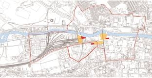
The OPW lands are adjacent to Dr Steevens’ Hospital and is a corner site that connects to the Military Road.
The hospital itself is rich in history and has been there since 1720. It was named after a physician called Dr Richard Steevens (1653-1710) whose sister Griselda Steevens used the inheritance her brother left her to open the hospital on condition that she could stay there for the rest of her life.
The hospital is now being used by the Health Service Executive for administrative purposes.
Plan for the hospital is to re-landscape the space in front of the building and create the Dr Steevens’ Hospital Park.
Next to Dr Steevens Hospital, situated on St Johns’ Road facing Heuston Station, the OPW Lands lie and it stretches further up on the left side where it runs along the Military Road.
There are big plans for the site along the Military Road. A five storey high building for commercial use and a six storey high building for residential use will be developed on this site.
The buildings will curve along the pedestrian and cycle link along the Military Road.
A you go down to the corner you find the OPW lands, there are a two National Monuments dating back to before the 1700’s in the OPW Park and these buildings will be preserved for future generation, so don’t worry this is not a complete “in with the new, out with the old” plan, somethings are here to stay.
Buildings that will go onto this site will be scaled down to two or three storeys high, to keep them on the same level as the National Monuments and residential towers reaching a height of seven storeys will go up along the IMMA Avenue and Cammock, further up from the Military Road.
Between Dr Steevens Hospital and the OPW Park there is enough space for a tall building and the suggestion is that it goes up as high as 15 storeys, for the possible use of a hotel or residential units.
The development are looking to integrate social and affordable housing, if that is to become a residential skyscraper, this is one of the three tall structures I mentioned previously.
Pedestrian and cycle routes will be improved all around the area, with pedestrian paths linking the new parks with the Irish Museum of Modern Art.
IMMA Avenue will become the pedestrian dominant link, and this avenue will run parallel with the Cammock river.
This is a very strategic plan the regeneration project is approaching for the Liberties environment and part of its strategy is to think green.
All the buildings and parks that will be incorporated with the new developments will all aim at energy management, water management and creating green spaces, excellent and important for those who have young children and need to save.
There will be numerous park areas on the St John’s Site surrounding the buildings and the reason why, is to absorb sound, dust and CO2.
Green parks will also increase air water content, filtration of water and regulation and regenerate the natural balance of the water in the environment and the most important reason for it some of us would believe: to provide social and leisure space for tourists, local residents, families with small children and workers.
All around from Heuston Station down St John’s Road and up the Military Road footpaths will be made wider for pedestrians and cyclist.
The basic idea is to encourage residents, tourists and workers to “think public transport” and to leave the car at home.
Bus lanes will run more often down these roads, serving the city centre and Heuston Station and connecting neighbourhoods.
Well that’s all folks, for the moment that is. Next week we will be back with Part Three to have a closer look at what else the Government has planned for the beautiful people of Dublinia.


Jacqueline, thank you very much for these interesting and informative pieces- I look forward to the next installment. Thanks again, Tom Grey.