Part One – Heuston Gateway Development Series
An English architect called Sanction Wood was commissioned to design Kingsbridge Station. The station opened in 1844.
The Easter Rising’s 50th anniversary changed all of this and Kingsbridge was renamed Heuston Station in 1966 in honour of Sean Heuston, one of the executed leaders of the Rising who used to work in the station’s offices.
Heuston Station is located on St. John’s Road West and is one of two main railway stations in Dublin; Connolly Station on Amiens Street is the other one.
There are four other commuter stations serving the inner city and they are connected to Connolly Station.
To get to Heuston is not difficult these days, thanks to the LUAS Red Line the Connolly and Heuston stations are now connected by tram.
Heuston Station is also linked to Bus Aras via the Red Line, bus route 145 connects Heuston to O’Connell Bridge and the 747 links Heuston to Dublin Airport.
According to the latest figures of the CSO “a total of 197.4 million passengers were carried on scheduled bus services, 32.6 million passengers travelled on the Luas and 37.8 million passengers travelled by rail in 2014”.
The latest figures also show that there was a 77.0% (3,014,937) increase in Dublin Bike journeys, up from 2013.
The Liberties Regeneration Strategy is the “Big Plan” for this part of the city and one of these days, if all goes according to plan, this WILL be the inner city (west).
The big news – Heuston Gateway is up for redevelopment! It is called the Gateway, because it is a gateway to the city from the west.
The plan for Heuston area is to connect the inner city and to extend it as far as Heuston.
For the moment Heuston is “way-out” here, but once all of the projects are finished, Heuston will be “in” the city.
Starting at the Heuston Gateway, the plan is to create an environment with less traffic, encouraging commuters and visitors to the city to use public transport instead.
Walkways will be widened, encouraging more people to walk into the city or to cycle as the environment is made safer and more approachable.
Guinness Brewery is adjacent to Heuston Station, has acres of lands bordering on Victoria Quay on the south-side of the River Liffey.
Three Guinness Sites, namely Site A, Site B and Site C, has been suggested as sites that can be developed for commercial use and at a later stage for residential use.
It has been proposed that in the next few years three tall buildings are to be erected at Heuston Gateway, three being the limit as far as height goes, and that these buildings will all be facing an eastern-western direction.
The idea behind the designs will be to prevent light and views from being blocked out from the west side.
The three tall buildings proposed are the Guinness Building, OPW Building and the CIE Building.
It has also been mentioned that there are several other suitable public buildings and institutions to be considered for development.
They include: the west end of Heuston Station; West Terrace Tall Building; Heuston Station Lands site; Hickeys site; National Museum site; Clancy Barracks; and Phoenix Park site on Parkgate Street on the Infirmary Road.
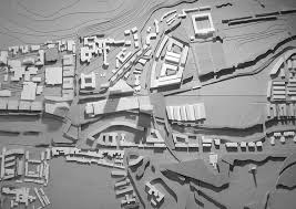
This week in Part One of the Heuston Gateway Developments Series we will take a closer look at the plans for the Guinness lands.
Three sites on the Guinness lands have been suggested for development and is the bigger project, because of its size and its location.
These sites are Site A, Site B and Site C. The only problem with these sites are, that they are so close to the Brewery, that noise level has to be considered when thinking of residential building.
Site A is located next to Steevens Lane near the old Cask Works. This site is not in use and has several empty buildings on the site, with one of them being used for office space at present.
The site is favorable for a few reasons: it is close to Heuston Station, the LUAS line and it is right opposite Dr. Steevens’ Hospital and St. Patrick’s University Hospital.
It is also easy to access the new Pearse Lyons Distillery, new National Children’s Hospital and Guinness Storehouse from here.
The site is potentially more suitable for high density use and could at a later stage be accessed via a road that connects Thomas Street to Victoria Quay.
It was proposed that a six story commercial development in a series of four blocks is to be build here, with the north block facing the Dr. Steevens’ Hospital.
Site B is on the corner where Heuston Square and Victoria Quay meets. This site has all the potential the first one has, but has a view of the river and the hotels on the other side, making it a site that is more commercially developable.
It has been proposed that a distinctive landmark six storey building for commercial and cultural use is to be developed on this site, with an entrance on the Heuston Square side.
Site C is the lands along the Victoria Quay on your way to town. This site overlooks the Collins Barracks, has views of the river and will also benefit from a thorough-way if Thomas Street opens to the Victoria Quay.
It was proposed that the buildings should stay at a lower level, so that the Guinness Factories and Storehouse and the church steeples will stay open to view on the north side of the river.
Six storey buildings are to build on this site, with breaks in between them, allowing for enough sunlight to reach every building.
Another suggestion is a wider footpath for pedestrians and cyclists, who will be accessing the environment and making their way to the Heuston Gate.
The site will include the preservation of two structures that are at present on this site; the original Guinness Gate Lodge and the pub on the corner off Watling Street.
To make this site, which is bigger than the other two more accessible, a new road branching off at Victoria Quay in line with St. John’s Road has been suggested.
Pedestrian access to the rear of the new development on Victoria Quay between Watling Street and Heuston Square has been proposed, so that there is a direct link between the station and the Digital Hub.
With all this in mind, the question is what happens to the Guinness UDV Brewery, how will this affected their workers and their industry?
DCC has said in their Strategy plan that nothing will change for the Brewery, the lands are important to the city as a business that employs people and their industry is greatly respected.
It will remain a Z7 zone and none of the developments will restrict in any way the present or future of the Guinness UDV Brewery.
The Z7 zone means that the area is protected for use of industrial creation and providing employment.
The site called Site B is designated to become a Z5 zone and the other two sites are designated for Z6 zones.
Stay with us for Part Two of the Heuston Gateway Series, next we will look at the OPW and CIE developments.


