The Fololowing article was written by an archaeologist named Antoine, we are currently trying reach him for further information. Fascinating Reading.
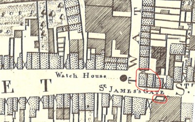
This April just gone, road works on James’/Thomas Streets have uncovered the foundations of mostly 18th century buildings facing James’ Gate on the corner of Watling Street, what follows is one architect who had access to the site’s appraisal of what was found. The buildings, has they would have been located in 1756, are marked in red in the above Rocque map extract.
The walls that have been uncovered are actually a mix mash of multiple phases of buildings over the century, with one built over the other. The Rocque-phase of 18th century buildings are probably the middle phase, demolished in the 1850s. Later on in the 1900s, there was a smithy located on the site and some remains of that were also uncovered. Walls from an early period, in particular, one large and deep masonry wall, made of large limestone blocks, without any obvious function, were found below those buildings. It is quite deep, and has been interpreted by one architect, as a potential early-post-medieval structural remain possibly associated with St. James’ Gate and has been preserved fully below the ground after it was surveyed.
A large brick culvert (ditch used for a water course) running under the buildings was also found, frequently altered during the 18th and 19th century. The 1848 5-foot Ordinance Survey map does show a watercourse running under buildings near there (albeit further east down the block). The piece found of the culvert was very interesting because it had features such as massive brick piers 1m thick, rounded to assist with water-flow, with areas for sluice gates and other control features. Perhaps part of a mill-race complex, which would be common to the area due to all the distilleries.
There is a theory it carried a branch of a watercourse that ran down there, across St. James’ Gate and down Watling Street. This might be called the ‘Glib Water’, but it is questionable that it exists anymore.
Further south from all that stuff beside the bank – under the actual road – a water course was also found. But this took the form of a very big ditch running east to west along James’ Street, so possibly representing the watercourse when it was uncovered. The ditch was backfilled in the 13th century and the backfill is packed (literally) with a very dense concentration of medieval artefacts, including large pieces of french jugs, floor tiles, and lovely decorated roof tiles that might be from a (demolished?) local religious building. After the ditch was backfilled (presumably they had rerouted this medieval watercourse first) they packed the soggy top of it with a thick layer of gravel, that sunk in slightly, and seems to have formed the sub-surface of a widened late medieval James’ Street similar in width to the current road. This ditch has been fully preserved under the ground and the path of the fibre-optic cable currently being laid here has been raised a little bit so that it does not touch the medieval feature.


